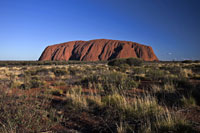
  Uluru Facts for Kids Uluru Facts for Kids
Enjoy our fun Uluru facts for kids. Understand what makes Uluru so special with our range of interesting information and trivia. Learn where Uluru is located in Australia, how it formed many years ago, how it got its different names, why the area is important to the local Anangu tribe, how high it is, and much more. | | |
The first foreign people to see Uluru were explorers led by English born Australian William Christie Gosse, his group set eyes on Uluru, 19 July 1873 and decided to call it Ayers Rock after Sir Henry Ayers, the Chief Secretary of South Australia at the time.
Uluru is estimated to be around 600 million years old, it originally would have sat at the bottom of a sea, but today it stands 348 m (1,142 ft) above the flat desert and 863 m (2,831 ft) above sea level.
Uluru is an inselberg (meaning island mountain), which is a prominent isolated bump or hill that rises abruptly from widespread flat plains in a hot, dry region. Its the hard rock of a mountain left over after softer areas have eroded away. Uluru is also often called a monolith, which is more of a vague geological term.
The rock has eroded valleys and ridges and little or no vegetation. The surrounding area however, has a number of springs, waterholes, rock caves, and ancient paintings.
Uluru is not the only rock formation in the area. Kata Tjuta also known as Mount Olga (or The Olgas) is a group of 36 large dome shaped rocks (originally being one massive monolith) located 25km (16mi) West of Uluru in the Northern Territory. The tallest of which is 546 m (1,791 ft). Uluru and Kata Tjuta are two major landmarks within the Uluru-Kata Tjuta National Park.
|

|
|